Wednesday, March 28, 2012

Captain's Log: Day 5

 Today we piled into the SUVs and drove down the coast to the Southern Point of the island, which is also the southernmost point in the U.S. After driving through small villages and windblown plains we finally arrived at the Point, where we left behind our cars and set off for the famous green sand beach. The 45 minute hike followed rugged dirt roads that wound back north-east along the coast.

Preparing for the trek 

 Gordon struts his stuff

The green beach flanked by the remains of a cinder cone

 Reckless driving by the cliff

 The descent down to the beach was particularly painful, as our skin was brutally abraded by blowing sand. It was well worth the pain though. The beach had some great body surfing waves, and perfect sandy slopes to tumble down. 


 Ian wins the competition to be first in the ocean. Worth landing head-first in shallow water? Ehh...

After walking back to the cars, we headed to one of the black sand beaches, which we were thoroughly whelmed by. It had some sea turtles and palm trees, but simply couldn't compete with the glory of the green beach. 

Proper spotting technique in action

Saturday, March 24, 2012

Captain's Log: Day 4


Day 4. With two websites predicting two opposite forecasts, we decided to take our chances and set out for the National Park. We soon realized that our efforts were rewarded since we were
lucky enough to witness an amazing spectacle...ERUPTION!

Except...not. We did hike on the devastation trail though and got a different view of Kilauea Iki which we had hiked on our first day. Staying on proper trails of course, we then hiked to Byron Ledge and got a great view of Halemaumau crater in the Kilauea Caldera. After taking in the view and discussing the potential threats of the smoke coming out of the crater, we headed back to the car just in time to escape a little drizzle.

Halemaumau Crater

Next we drove down Hilina Pali road and soon found ourselves parallel to the fault that separates the fast moving land (seaward) from the slow moving land (landward). As we were looking for the "end" of the fault, we decided to leave the road and climb onto it. Paul discovered the "easy way in" but considering his difficulties we all found another way onto the rocks.

Paul found the perfect route

When we were satisfied with the discoveries we had made, Paul and Steve got the cars while the group kept walking down the road. Gordon often found something interesting and ran into the woods so we played Gordon Brown, our very own version of Marco Polo, in order to locate him. We found Gordon, the boys didn't injure each other playing rock tag and we all got back into our cars.
Top of the fault

Our next stop was Hilina Pali (Hilina Cliff) where the view was breath taking...well at least to most of us.
Enjoying the view...
...too much for Ian to handle

We hiked down the cliff a little ways to enjoy the geology of the area and again got into our vehicles right before the rain hit. We headed back to the cozy Breakfast Lanai, turned it into a Lunch Lanai, and enjoyed a hearty meal. Having exhausted all the sunshine in the morning, we explored the Jagger Museum in the afternoon to learn more about the Hawaiian Gods and other cool stuff in the park. Seismic activity meters indicated that an earthquake had hit the island the day before but (un)luckily for us we did not feel it.

Needless to say, it was all pretty neat.


Captain's Log: Day 3

Day 3. There exists an hour of the day when no self-respecting college fellow should have to wake up, and I hereby decree that hour is any time before 9 in the hours before noontime. So when we were told to wake up at the crack of yesteryear to load up, several complaints were aired. But a few stayed strong and fought the urge to let out a belch or moan about the departure time, and so we set off for a very high day in the mountains. The story of Day 3 can be told in several units of time, but I'll select one that was most appropriate for this day: the number of times we told Johanna she should be careful of fainting on Mauna Kea. (Earlier on the trip, Johanna gave a riveting account of how she fainted in a bunch of running races and somehow that related to her fear of blood and/or needles.) Let T = the number of times we mentioned to Johanna that she was liable to faint in thin air.

T=0. We loaded up the MANhicles, which had become two because alas each had both guys and girls in them that day. We then headed down in the direction of the airport to pick up Paul's friend Mike Garcia, who seems to have been unendingly knowledgable about volcanoes. Before we picked up Mike, someone remembered Johanna's plight of fainting, and T soon increased to at least 5. The airport, at approximately zero feet above sea level (plus or minus 100 feet, we scienced it) provided an excellent starting point. We soon began to climb northwest up and out of Hilo, and into the saddle between the two giant volcanoes. At 6,000 feet, T≈12, because every time our ears popped, it reminded us that we needed to make sure Johanna was okay.

Rain clouded our way for much of the ride up, and it was not until we reached the visitor's center at roughly 9,000 feet or T=14 that we emerged, heroically, from the mist. Our rental car smelled like someone had lit it on fire slowly and methodically, starting at the tires, but Paul checked that the parking brake was off like six or seven times, so it was okay.

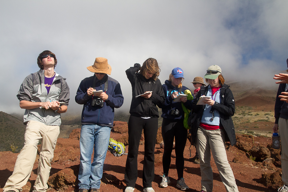
We then hiked up a small cinder cone and successfully answered like 1 in 5 of Mike's questions. It looked like it would rain, so Kalle put on his plastic bag skirt/kilt, or skillet for short.

Just a man and his skillet

Head-scratching and sky-looking during a series of trick questions.

The hiking at 9,000 wasn't so bad. Johanna was doing fine. At the bottom, T=16 because we discussed at length how she hadn't fainted yet but a quick science calculation told us we still had almost 5,000 feet yet to climb, so we reminded her to be careful again. Roadhouse.

However, up at 12,000 feet, T began to approach 100. Our walk turned to a crawl as the mountain air laid bare the lungs of even the fittest of athletes. John acclimated to altitude especially poorly, and could be seen lying on his back regaining his breath or running off to find a place to leave part of his morning's Breakfast Lanai findings on the mountain. Tommy was seen laughing at him. We made our way up to a lake, apparently the highest in the Pacific, and gladly ate our lunches and tried unsuccessfully to refrain from complaint and/or weakness. Mike said some more things about rocks...things that most of us enjoyed but which may not enthrall the reader. Because we were asking Johanna if she was okay roughly every other second, the value of T was quickly escaping the realm of imagination.

Altitude gets the better of Ian's face

The highest lake in the Pacific. By our calculations, probably bottomless.

We hiked back down to the cars, and we were glad not to have to walk much further that day. Snow coverage in some places increased as we made our way to the top, and Tommy and Ian saw some ski lines that brave individuals had carved some weeks earlier. Some Haters said that they weren't ski lines but melt features.

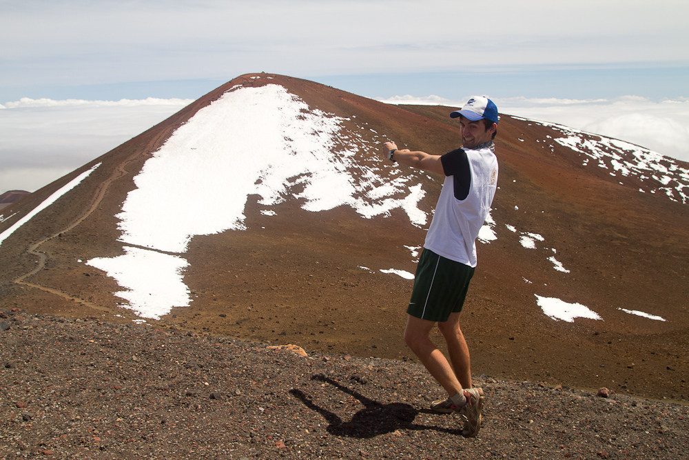
At the top, T, for our purposes, was roughly infinity plus or minus, to quote John, a crizazy, zazy, crazy number. Kalle tried to drive off a cliff and hold a distant cinder cone in his hand (pictured below) but was unsuccessful on both counts.

Bros bros bros! You want some cones, bros?

Kalle nearly drives off a cliff

Some astronomy things. Well-placed out of the range of tsunami, quite poorly placed out of the range of reckless driving.

Tommy reenacts Pele's birthing of the entire mountain of Mauna Kea. Notice Johanna supporting herself AND Tommy!

Proof all of us were still standing at the top

Kalle attempts to hold a cinder cone in his hand, but the cinder cone nimbly escapes his grasp.

After blowing up the Keck Telescopes' public bathrooms, we headed back down into the saddle, where we saw a wall diverting a large Mauna Loa pahoehoe flow surprisingly successfully. We were thoroughly exhausted from hiking like 1500m to and from the lake and 50m around the summit, but we had survived, and no one had fainted. Those of us poking fun at Johanna were all proven to be Big Ol' Haters, similar to the ones that tried to say there were no ski tracks but at least...3 times that size. Final counts for T could not be obtained because they were too damn high, which ironically is also sort of how we felt about the mountain. Did I take the T joke too far? Yes. Roadhouse.

How neat is that??

Friday, March 23, 2012

Captain's Log: Day 2

Today we headed out on the Chain of Craters Rd. to look at the many pit craters that dot the Kilauea East Rift Zone. Along the way we stopped at a 1973 pahoehoe flow. Leaving our cars behind, we set off across the flow towards part of the Koa'e fault scarp. As we crossed the flow we were surprised to find great examples of lava trees standing above the rest of the lava.

 Exploring the '73 flow

 This is a burnt tree. You can tell it's burnt by the way it is.

 Ian delivers the gospel according to Pele from atop a lava tree, while Gordon is swallowed by a hungry lava tree.

Across the street, John discovered a precarious way down to view another crater. This crater had a number of spatter cones that resembled the "dribble castles" that many of us had made as kids.

Calculating the depth using the rock-toss method and contemplating hang-gliding down

 Checkin' out the splatter cone

New age art

Johanna almost falls in the crevasse

We continued down Chain of Craters Rd. stopping occasionally to enjoy beautiful vistas of fault scarps and the ocean. 

A landscape shot

The end of the road has been overrun by recent lava flows, so we walked the last half mile stretch to where the pavement ended and lava began. We were able to take a few pictures before a torrential downpour hit, sending us running for the cars.

Watch out Rod, volcano poop!

Reckless driving near the lava flow

Back at the Breakfast Lanai, we enjoyed a hearty meal of burritos as we planned our trip for the next day.

Pretty neat.

Breaking News from Day 1

Closed circuit television caught these two men "red-handed" as they tried to launch an assault on the security of this ash mound.


How neat is that?

Captain's Log: Day 1

We got up early the morning after our long journey to the Big Island and got ready to set off for Hawaii Volcanoes National Park. Although we were exhausted from a ton of flight time the day before, we had the time change on our side in the morning. The guys got up extra early to eat all the breakfast food at the Breakfast Lanai and secure seats in the MANhicle, two moves which were key to success.

Fighting the travel weariness

At the park, we drove to Kilauea Iki, a large pit crater near Kilauea Caldera that last erupted in 1959. The hike in provided Gordon ample opportunity to inform us of the local flora. Once on the opposite side of the pit, we hiked down onto the crater floor. We spent the next hour and a half scrambling and climbing across the crater floor, generally in places off the acceptable path.

Enjoying the view of Iki

Paul drops some knowledge bombs on the group

Trek around Kilauea Iki

Taking the path less beaten off the crater floor

Big 'ol fractures

Defiling National Forest drill holes

Hiking across the floor, someone asked if the drill holes the USGS used to the determine depth of magma were still there. After some looking, we discovered that they indeed still existed. We decided to measure the depth of the hole we uncovered using the rock-drop method. Science.

After a quick lunch break back at ye ol' Lanai, we headed back out to the park to Kipuka Puaulu, a small vegetated "island" surrounded by lava. The trip around the footpath took an unexpected turn when we discovered the caved-in entrance to a millennia-old lava tube. Breaking out our headlamps, we discovered that it continued for quite aways underground. Disagreeable mustiness and general unease regarding the 12+ legged monster caused us to abandon our search for another entrance.

Exploring the lava tube

Emerging from the tube

This tree fits five people!

Before heading back home for the day, we stopped by some of the best tree molds on the islands, which form when lava cools around tree trunks.

I bet a European explorer discovered this... and he was probably wearing a feathered hat

End Captain's Log: How neat is that?